
If you are researching property in Imus, Cavite, you are probably asking this question because you have seen footage of flooded streets in the south — or because someone warned you. The concern is legitimate. Imus has flood-prone areas, and buyers who skip this part of their due diligence sometimes discover it after they have already signed.
But Imus is not uniformly flood-prone. The city covers a wide geography, and the flood risk varies significantly depending on where exactly the property sits — which barangay, which elevation, and how close it is to waterways. The honest answer to “Is Imus Cavite flood-prone?” is: it depends on where in Imus.
This guide maps the risk by area, explains what drives flooding here, and tells you exactly what to check before committing to a property.
Why Imus Has a Flood History
Imus sits in the Cavite lowland region, and several factors combine to make parts of it genuinely vulnerable to flooding during heavy rain events.
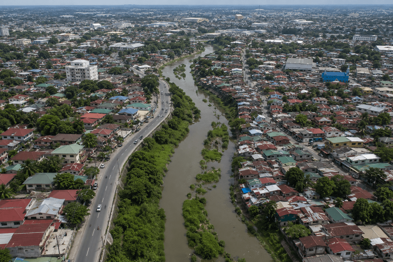
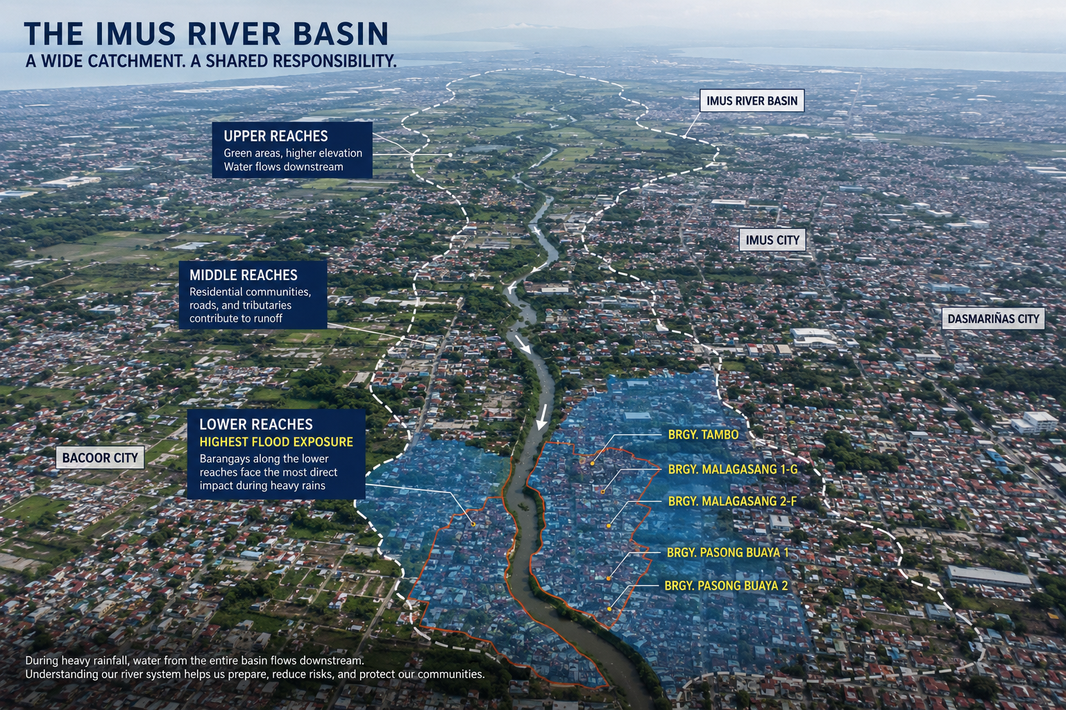
The most significant is the Imus River. The Imus River basin drains a large catchment area that extends through Silang, General Trias, Dasmariñas, and Tagaytay — and the water eventually funnels down through Imus toward Manila Bay. When major typhoons hit or prolonged monsoon rains saturate the watershed, the river swells and its lower reaches overflow. Barangays along or near the river are the first to feel this.
The second factor is topography. Imus has an average city elevation of around 34 meters above sea level, but that average masks significant variation. Its lower-lying barangays — particularly those closer to the river and toward the bay — sit at much lower elevations. Meanwhile, inland and upland areas can be considerably higher, which changes their flood exposure substantially.
A third factor is drainage capacity. Rapid urbanization in Cavite over the past two decades has increased impervious surface coverage — more roads, roofs, and concrete — which means more runoff and less natural absorption. Drainage infrastructure in older and denser parts of Imus has not always kept pace with development, and clogged waterways remain a recurring complaint to the city government.
None of this is unique to Imus. It applies to much of Cavite's urbanized zone. But it means that in the right combination of typhoon strength, monsoon timing, and drainage failure, flooding in certain areas is not an unusual event — it is a regular one.
Higher-Risk Areas: What to Know
News reports, government flood advisories, and academic flood mapping research consistently point to the same clusters of barangays as flood-affected during major rain events in Imus. These are not isolated incidents — they are recurring patterns.
Areas that appear repeatedly in flood-related reports include:
- Medicion barangays — Medicion 2-A and Medicion 2-F have been documented as severely flood-affected during heavy rain events, with aerial footage from as recently as July 2025 showing submerged roads and residences.
- Bayan Luma — the Bayan Luma cluster has appeared in evacuation records and flood reports, with the barangay hall serving as an evacuation center during major weather events.
- Pasong Anabu — documented as an area where roads become impassable during flooding.
- Malagasang II-C — appeared in evacuation records during Typhoon Paeng in 2022.
- Carsadang Bago — mentioned in government flood response records alongside other affected barangays.
The common thread among these areas is proximity to the Imus River or its tributaries, lower relative elevation, or both. When large volumes of water move through the watershed during a typhoon, these are the first barangays to experience overflow and inundation.
Important: Flood risk is not static. Infrastructure improvements, canal clearing, and drainage upgrades can change conditions over time. The areas above reflect patterns from recent news and government records — always verify current status through official flood hazard maps before purchasing.
Lower-Risk Areas: The Inland Corridor
Not all of Imus floods. The city's inland and elevated zones — those further from the Imus River's lower reaches and sitting at higher ground — generally experience lower flood exposure than the areas listed above.
The broader inland corridor of Imus, including areas like Alapan, portions of Anabu, and Bucandala, tends to sit at relatively higher elevations compared to the riverside and coastal-adjacent zones. This does not mean these areas are flood-immune — Alapan I-B has appeared in city drainage clearing programs, and Anabu 2-B has seen waterlogging during heavy rain events — but their exposure to the severe, prolonged inundation that affects riverside barangays is generally lower.
The key distinction is between drainage-related flooding (temporary waterlogging during extreme rainfall, which can affect almost any urban area) and riverine flooding (overflow from the Imus River or its tributaries, which follows more predictable geographic patterns tied to elevation and proximity to waterways). Properties far from waterways and on relatively higher ground face mainly the former — which is manageable and typically clears faster.
Lancaster New City, where One Lancaster Park is located, sits within Barangay Alapan IIB in Imus. The area averages around 19 meters above sea level, placing it on higher ground relative to the lower-lying riverside zones. When we ran the specific GPS coordinates of One Lancaster Park (14.3988, 120.9082) through HazardHunterPH — the official GeoRisk Philippines hazard assessment tool — the site returned a flood susceptibility rating of “Most likely suitable for development, needs further validation.” That is the MGB's lowest risk classification for flood susceptibility. Historical flooding in older, lower sections of Lancaster during extreme weather events has been reported, so this is not a blanket assurance — but the official data for One Lancaster Park's specific location is on the favorable end of the scale.

What to Check Before You Buy: The Due Diligence Steps
Knowing the general risk profile is a starting point. For any specific property, you need to do your own verification. Here is the standard checklist.
1. Check the DPWH Flood Hazard Maps
The Department of Public Works and Highways (DPWH) publishes flood hazard maps that cover Philippine cities, including Imus. These maps use a three-level hazard classification: low (yellow), medium (orange), and high (red). The Imus Flood Map is accessible through the DPWH website and shows which areas fall under which hazard category.
Start here before anything else. A property that falls in a red zone on the DPWH map carries real risk that no amount of developer marketing should override.
2. Use HazardHunterPH
HazardHunterPH (hazardhunter.georisk.gov.ph) is a free online tool from GeoRisk Philippines — a joint project of PHIVOLCS and DOST — that lets you look up the flood susceptibility rating of a specific location by address or by pinning a point on a map. It is designed exactly for buyers and landowners doing pre-purchase due diligence. Run the specific address of any property you are considering through this tool before you commit.
3. Ask the Developer Directly — and Ask for the Evidence
When inquiring about a preselling condo or house and lot, ask the developer's team directly: “What is the flood hazard classification of this specific lot or building footprint?” A developer operating in good faith will have this information and will share it. They should be able to show you the relevant hazard map excerpt or the geohazard assessment for the project site.
If a developer cannot answer this question clearly or deflects with general reassurances about “high ground,” that itself is a signal. The DHSUD License to Sell requirement under Presidential Decree 957 mandates disclosure of material facts about the property — flood hazard exposure is a material fact.
4. Check the LiDAR Flood Maps from UP DREAM
The University of the Philippines DREAM Program (Disaster Risk and Exposure Assessment for Mitigation) has published detailed LiDAR-based flood maps for the Imus River basin as part of the national Phil-LiDAR program. These are more technically detailed than the DPWH maps and are available through the LiPAD portal (lipad-fmc.dream.upd.edu.ph). If you want the highest-resolution publicly available flood data for Imus, this is where to find it.
5. Visit the Site — at Different Times
Visit the property during or right after heavy rain if possible. You will see firsthand how drainage performs and whether surrounding streets pool water. Also look at the road elevation relative to the lot — a property that sits lower than the surrounding road level can accumulate runoff from above even in light rain.
Buyer's principle: Flood maps are the ground truth. Developer assurances and marketing materials are not a substitute. Run every property you are serious about through the official hazard tools before you make a financial commitment.
Does a Flood-Adjacent Area Mean You Should Not Buy?
Not necessarily — but it changes the calculus. Some considerations:
- Low-hazard classifications are not the same as no-hazard. Even areas rated low on flood hazard maps can experience drainage flooding during extreme events. The question is frequency and depth.
- Flood risk affects resale value and rental appeal. Properties in documented flood-prone barangays are harder to sell and command lower rents, regardless of their individual unit condition.
- Insurance is available but not always cheap. Flood coverage is available from Philippine non-life insurers, but properties in higher-risk areas attract higher premiums or may face exclusions.
- Infrastructure improvements can change the picture. The Imus City government has been active in drainage clearing and canal expansion. Future flood control infrastructure funded at the national level can also reduce risk in previously vulnerable areas. Monitor this if you are considering a medium-risk zone.
How This Applies to Condo Buyers Specifically
Condo buyers have one advantage over house and lot buyers when it comes to flood risk: vertical separation. A unit on the third floor and above of a mid-rise building is not directly threatened by street-level flooding the way a ground-floor house or lot is. The risk for condo buyers is more about access — getting in and out of the building during flooding — and whether the building's ground-floor facilities (lobby, parking, mailboxes, utilities) are elevated or protected.
When evaluating a preselling condo in Imus, ask: how is the building's ground floor designed relative to the street level? Is there a raised podium or step-up entry? How is the basement or parking level waterproofed and drained? These are practical construction questions, not just marketing ones, and a reputable developer should have clear answers.
One Lancaster Park by PH1 World Developers sits within Lancaster New City in Barangay Alapan IIB — positioned at a higher elevation relative to the lower Imus River corridor. As with any property, our team recommends buyers verify the specific building footprint against current DPWH and HazardHunterPH data independently. The responsible question to ask any developer — us included — is not “are you flood-prone?” but “what does the hazard map say for this specific location, and what can you show me?”
Frequently Asked Questions
Is all of Imus, Cavite flood-prone? No. Imus has significant variation in flood risk by area. Barangays along the lower Imus River corridor — such as portions of Medicion, Bayan Luma, and Pasong Anabu — have documented flood exposure. Inland and elevated zones carry lower risk, though no urban area is entirely immune to drainage flooding during extreme rainfall.
Which tool should I use to check flood risk for a specific address? Start with HazardHunterPH (hazardhunter.georisk.gov.ph) — it is free, built for this purpose, and gives barangay-level flood susceptibility data. Cross-reference with the DPWH Flood Hazard Maps, which show three hazard levels across the city. For maximum resolution, the UP DREAM LiDAR maps via the LiPAD portal give the most detailed publicly available data for the Imus River basin.
Does a mid-rise condo protect me from flooding? Partly. Upper-floor units are not directly inundated by street flooding. However, ground-floor facilities, building access, and parking are still affected. Ask the developer about the building's ground-floor elevation and how parking and utilities are protected. This is a reasonable due diligence question for any condo purchase in a flood-adjacent area.
What is the Imus River's role in flooding? The Imus River drains a large watershed covering multiple cities and municipalities in Cavite. When the watershed receives heavy rainfall — particularly during typhoon season — the river's flow can exceed its channel capacity, causing barangays in its lower reaches to flood. This is a documented and recurring phenomenon. Barangays further from the river and at higher elevations are less exposed to this type of flooding.
Is Lancaster New City flood-prone? Parts of Lancaster — particularly older, lower sections — have experienced flooding during severe weather events. The Advincula Avenue area of Lancaster New City has a recorded elevation of approximately 15 meters above sea level, which is on the higher side relative to the most flood-exposed zones in Imus. Individual buyers should verify their specific unit and building address against current official hazard maps rather than relying on general characterizations.
Does flood history affect property resale value? Yes, it can. Properties in well-documented flood-prone barangays generally command lower prices and are more difficult to sell than equivalent properties in lower-risk areas. This is worth factoring into any investment calculation, not just the upfront cost.
The Bottom Line
Imus is not uniformly flood-prone — but it is not uniformly safe either. The honest answer is that it depends on where in the city the property sits, how close it is to the Imus River, and what the official hazard maps say about that specific location. Anyone who tells you otherwise — in either direction — is oversimplifying.
Do the verification. Run the address through HazardHunterPH. Pull the DPWH flood map. Ask the developer for the specific hazard classification of the project site. These steps take less than an hour and can save you from a very expensive mistake.
If you are evaluating a unit at One Lancaster Park and want a straight answer about how the specific building sites compare to the official hazard data, our team can walk you through it — no sales pressure, just the information you need. You can also start with our mortgage calculator to work out the financing side while you complete your location due diligence.
For a broader look at what daily life in Imus is actually like — traffic, schools, malls, and community — see our honest guide to living in Imus, Cavite. And if you are still weighing Cavite against other options, our Cavite real estate investment guide covers the infrastructure and appreciation case in detail.